



Manas Kumar Satpathy
India’s irrigation history is usually told as a story of engineering triumph: dams as the “temples of modern India,” millions of hectares of “irrigation potential” created through major and medium projects. Yet a more basic question receives little attention: how did a civilisation that once managed water through millions of distributed, locally adapted systems come to imagine irrigation almost entirely through centralised projects?
The question is not academic. Roughly half of India’s net sown area remains rainfed; government data show that even after the country’s full irrigation potential is realised, about 40 per cent of net sown area will still depend on rainfall alone. These rainfed tracts, concentrated in the Deccan Plateau, Bundelkhand, the Chotanagpur Plateau, southern Odisha, southern Rajasthan and the tribal belts of Maharashtra, Telangana and Jharkhand, nonetheless account for an estimated 87 per cent of the country’s coarse-cereal output, 85 per cent of pulses and 72 per cent of oilseeds, besides carrying a disproportionate share of its poorest districts and its tribal population. Ignoring these regions in irrigation policy means ignoring the areas that supply most of the nation’s coarse grains, pulses and oilseeds.
The paradox deepens on closer look. Much of peninsular and central India receives 700 to 1,400 millimetres of rain annually, comparable to several intensively irrigated regions of the world; yet irrigation coverage there remains far below that of the canal-fed north-west. Rainfall alone cannot explain this. Nor can capital investment alone. The explanation lies in a historical transformation in the relationship between landscape, technology, institutions and the state.
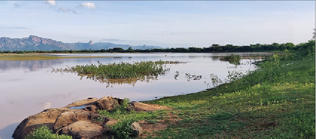
Long before hydraulic engineering became a modern profession, Indian societies had built remarkably sophisticated, ecologically adapted water systems: the tanks of the Cholas and Kakatiyas, the johads of Rajasthan, the ahar-pyne systems of Bihar, the phad systems of Maharashtra, the kuhls of the western Himalaya. Together these constituted one of the world’s largest decentralised irrigation civilisations, sustaining not just crops but groundwater recharge, flood moderation, fisheries and livestock within a single landscape.
This essay argues that India’s central irrigation challenge is not a choice between big dams and small structures; such binaries obscure the real issue. The task is to move from a project-based conception of irrigation to a landscape-based conception of water resilience. A project delivers water to a command area; a landscape stores, infiltrates, redistributes and recycles water through interconnected ecological processes. Understanding why India drifted from the second logic to the first, and how it might recover the first without abandoning the achievements of the second, is the focus of what follows.
India’s First Irrigation Civilisation: Engineering with the Landscape
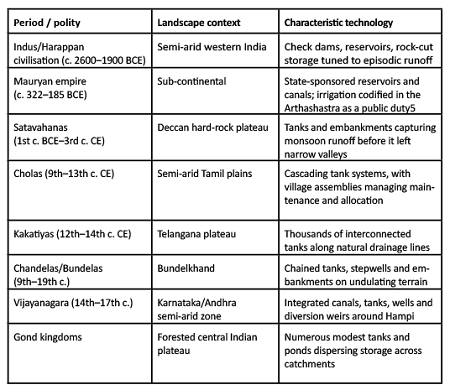
Long before irrigation departments or river-valley projects, the subcontinent had evolved an extraordinary repertoire of locally adapted water technologies, each responding to the hydrology of its landscape rather than the reverse. The table below illustrates the range.
The Sudarshana Lake near present-day Junagadh, first built under Mauryan administration and repeatedly repaired by later dynasties over several centuries, illustrates a recurring feature of this tradition: water systems were long-lived public assets requiring periodic adaptation rather than one-time projects.
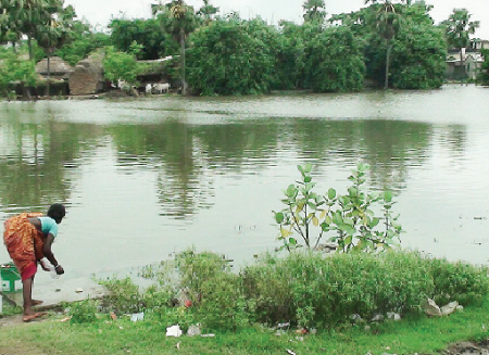
The Chola case deserves a closer look because it is often cited without explaining the institutions behind it. Thousands of interconnected tanks across the Tamil plains were organised into cascading systems, in which the overflow from one tank fed the next downstream, maximising the use of a single watershed’s runoff before any of it reached the sea. Village assemblies handled maintenance, water allocation and conflict resolution on a day-to-day basis, while royal authority financed major repairs and expansion, an arrangement that distributed operational responsibility to the local level while reserving capital-intensive works for the state, a division of labour modern irrigation bureaucracies have found difficult to replicate. Centuries later, in Telangana, the Kakatiyas faced similar hard-rock water conditions and came up with a similar solution. They built thousands of tanks along natural drainage channels. Many of these, including the Ramappa and Pakhala tanks, are still functioning after nearly 800 years. Their durability challenges the idea that small-scale irrigation systems are short-lived or unscientific.
Viewed together, these examples reveal a pattern that is easy to miss if irrigation history is read as a march from “primitive” to “advanced” technology. What actually drove change was continuous adaptation to ecological diversity. Across the gentle gradients of the Indo-Gangetic plains, diversion canals made sense; across the hard-rock geology and seasonal streams of peninsular India, tanks became the dominant technology; in the arid tracts of western India, stepwells and kunds emphasised storage and groundwater access; in the Himalaya, steep gradients favoured gravity-fed kuhls carrying snowmelt to terraced fields. No single engineering doctrine dictated this variety; intimate, accumulated observation of local hydrology did. India’s pre-colonial irrigation landscape is best understood not as a collection of isolated structures but as a mosaic of distinct hydrological cultures, each an evolving dialogue between people and place, and each capable of sustaining fisheries, livestock, groundwater recharge and flood moderation within a single, unified landscape rather than treating each function as a separate sector.
What made these systems durable was not simply engineering but the institutional web around them. A common but incomplete explanation is that these tanks endured because local communities managed them, maintaining the structures and distributing water fairly. In his influential ethnography of Tamil Nadu’s tank systems, the anthropologist David Mosse shows that tanks functioned not because villagers pursued an abstract common good but because water management was embedded in overlapping structures of land tenure, caste obligation, temple endowment, taxation and local political authority. Hydrology shaped institutions and institutions in turn sustained hydrology: tanks required coordinated desilting and rotational distribution rules; access to water was linked to obligations of maintenance labour; temple endowments gave donors religious merit while giving rulers political legitimacy for sponsoring public works and revenue extraction depended on a productive countryside, so neglecting irrigation threatened the fiscal base of the state itself. Remove any one of these elements, whether labour mobilisation, religious legitimacy or the ruler’s own fiscal interest and the physical structure alone could rarely survive. This is a crucial corrective to the romantic idea that pre-colonial systems ran themselves through spontaneous community harmony. They were contested and unequal along lines of caste, class and gender and required continuous political negotiation between cultivators, elites and officials over head-reach and tail-end access, cropping choices and tax obligations. They were, nonetheless, landscape-scale socio-ecological systems in a sense that modern irrigation planning rarely captures, integrating agriculture, groundwater recharge, fisheries and flood moderation within a single institutional order.
Colonial Disruption: From Landscape Institution to Hydraulic Project
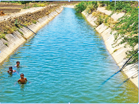
The colonial transformation was not simply a shift from small systems to large canals; it was a change in how water itself was imagined. Large canals offered the colonial state something dispersed tanks did not: a command area that could be surveyed, financed and taxed through a centralised bureaucracy. From the perspective of a revenue-collecting state, canals were not merely irrigation works; they were instruments of territorial administration, in a way that thousands of dispersed tanks and village bunds, however economically valuable, could never be. Nineteenth-century British engineers, trained in a tradition that prized standardised hydraulic control, reinforced this preference: monumental canals appeared modern and administratively legible, while India’s decentralised systems seemed fragmented and locally idiosyncratic, dependent on social arrangements that colonial officials neither fully understood nor trusted. As a result, irrigation increasingly came to be treated as an engineering problem to be solved by a department, rather than a socio-ecological relationship to be sustained by a community.
The institutional break this produced was profound. Traditional irrigation had linked engineering, land rights, labour and political authority in a single system; colonial administration separated these into compartments, engineers designing structures, revenue officials assessing land, courts adjudicating disputes, bureaucracies managing delivery. Colonial law simultaneously strengthened the principle that water was ultimately subject to state authority, eroding the legal and fiscal foundation of customary local institutions. Maintenance responsibilities became uncertain almost everywhere; communities often retained the expectation of access without retaining the authority, resources or labour-mobilising capacity that had previously kept a tank functional.
The result was not the immediate disappearance of traditional irrigation. Many tanks, johads and ahars continued to function for decades, in places for over a century, but the underlying institutional ecology that had sustained them was steadily weakened. India did not simply move from indigenous to modern technology; it moved from landscape-based water governance to project-based hydraulic administration, an intellectual shift that would outlast colonial rule itself. Independent India would inherit not only canals and reservoirs but the professional culture and development imagination of the hydraulic state, and it is this inheritance, more than any single policy choice, that continues to shape irrigation planning today.
Independent India: Continuity More Than Rupture
Independent India is often described as having broken decisively with colonial irrigation policy in favour of a developmental vision built around dams. The break was real at the level of political purpose; it was far less complete at the level of institutions. India inherited specialised irrigation departments, engineering curricula, project-appraisal methods and financing mechanisms built around centralised public works, an inheritance that shaped what independent planners considered feasible, measurable and modern.
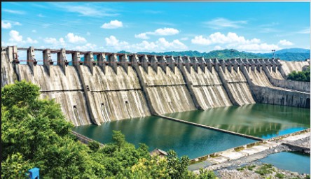
Large dams also carried immense symbolic weight. Speaking at the inauguration of the Bhakra-Nangal canal in July 1954, Jawaharlal Nehru famously called dams the “temples of modern India.” The description was not merely engineering admiration; for Nehru and his contemporaries, projects like Bhakra, Hirakud and later Nagarjuna Sagar embodied scientific progress, self-reliance and the capacity of a new democracy to mobilise resources at scale. These achievements should not be understated; the Green Revolution would have been inconceivable without them. The difficulty is that a model suited to broad alluvial river basins was increasingly extended to plateau and rainfed landscapes with entirely different hydrology, where seasonal streams, hard-rock aquifers and fragmented catchments favoured distributed storage and recharge over centralised diversion.
None of this is an argument against the dams themselves, and it is worth being explicit about that, since the counter-argument is an obvious one: a food-deficit, rapidly industrialising country in the 1950s and 1960s could not plausibly have met its needs through decentralised tank restoration alone, and large multipurpose projects delivered genuine, measurable gains in food security, hydropower and flood control across large parts of north-western and southern India. Nehru himself, within a few years of coining his famous phrase, revised his own enthusiasm considerably, coming to describe an excessive Indian fondness for outsized projects as a kind of gigantism. The issue this essay raises is not whether India should have built Bhakra, Hirakud or Nagarjuna Sagar; it is whether a model justified by its success in broad alluvial basins should have been allowed to become the only lens through which irrigation was subsequently imagined, including in landscapes for which it was never designed.
This bias was written into the very vocabulary of planning. Government classification still divides irrigation into major projects (culturable command area, CCA, above 10,000 hectares), medium projects (CCA between 2,000 and 10,000 hectares) and minor irrigation (CCA of 2,000 hectares or less). The terminology looks administrative; in practice it channelled political attention, finance and professional prestige toward major projects, while minor irrigation, encompassing tanks, ponds, wells and diversion channels that collectively sustain millions of rainfed farmers, became bureaucratically “minor” regardless of its cumulative significance for livelihoods and groundwater recharge.
Planning indicators reinforced the same bias. Storage capacity created, canal length constructed and command area developed are excellent measures of project completion; they say almost nothing about groundwater recharge, soil moisture, reduced runoff or the resilience of a watershed. Since landscape-scale outcomes were hard to measure with the tools available at the time, they were rarely considered when defining success. This omission was of limited importance in canal-fed plains but became increasingly consequential in rainfed upland areas.
A parallel shift took place in how traditional systems themselves were perceived. Earlier generations had regarded tanks, ponds, bunds and diversion channels as essential public infrastructure suited to local landscapes; post-Independence development discourse increasingly treated them as relics of an earlier technological era, associated with low productivity and administrative inefficiency rather than with centuries of proven resilience. The irony is worth stating plainly: many traditional systems had survived for generations with modest recurring investment, while many modern irrigation projects have required continuous financial support for canal lining, desilting and rehabilitation merely to sustain their original design capacity. The scale of this continuing liability is easier to see than official statistics usually admit. Applying the Twelfth Finance Commission’s own maintenance norms, ₹600 per hectare of utilised irrigation potential and ₹300 per hectare of potential created but not yet utilised, to the roughly 113 million hectares of major, medium and minor irrigation potential the country has created, works out to a national operation-and-maintenance requirement in the range of ₹5,000 to 6,000 crore a year merely to keep existing infrastructure functioning at its design capacity, before a rupee is spent on anything new. Multiple Finance Commission and Central Water Commission reviews have found actual state allocations running well short of this norm, with much of what is sanctioned consumed by establishment costs rather than physical repair, producing the silting, breached bunds and falling conveyance efficiency that later require emergency rehabilitation loans or renewed capital assistance merely to restore a canal system to its original design performance. According to government data, almost 29 million hectares of irrigation potential remains unused, showing how costly delayed maintenance can be. The view that the first approach was backward and the second represented progress reflected changing ideas about development rather than a purely engineering judgement.
None of this diminishes the twentieth century’s real achievement. The developmental state modernised irrigation engineering with genuine success in the alluvial basins for which it was designed. It modernised the science of landscape hydrology far less. Engineering advanced faster than ecological planning and institutional specialization advanced faster than institutional integration; projects grew more sophisticated even as landscapes grew more fragmented. Seen this way, the history of irrigation after Independence looks less like a revolutionary break from colonial policy than its expansion under democratic developmental objectives: colonial administrators centralised irrigation to improve fiscal control, independent India centralised it to promote agricultural development, and in both cases water was understood chiefly as something to be planned through projects, managed by specialised bureaucracies and evaluated through engineering output, with the landscape itself gradually disappearing as the primary unit of analysis.
Why Plateau India Remained Behind: A Political Economy of Landscape Mismatch
The uneven geography of Indian irrigation is often attributed to natural endowment: plateau regions have difficult terrain, hard-rock geology and few perennial rivers. There is truth in this, but it does not explain why regions receiving 700 to 1,400 millimetres of rainfall, comparable to or exceeding that of intensively irrigated regions elsewhere, remained predominantly rainfed. The deeper answer lies in a mismatch between landscape hydrology and the institutional logic of irrigation planning.
The Indo-Gangetic plains and the peninsular plateaus are, hydrologically, different worlds. Broad alluvial valleys with deep aquifers and gentle gradients favour large, contiguous command areas served by a single reservoir or perennial river. Plateau landscapes, by contrast, are defined by hard-rock geology with limited groundwater storage, undulating terrain, first- and second-order streams and highly seasonal runoff. These landscapes do not lack water; they lack the physical opportunity to store it in a few large locations. Water exists but is dispersed in space and concentrated in time, a hydrological condition Rockström and Barron describe more generally: in much rainfed agriculture the binding constraint is not total rainfall but the capture of water during short, intense periods before it runs off, a gap that distributed water-harvesting can close even where average rainfall appears adequate.
Perhaps the sharpest way to state the problem is that plateau India does not suffer chiefly from water scarcity but from short water residence time. Most of its rainfall arrives within a few weeks of the south-west monsoon; without distributed storage and recharge structures to hold it, much of that rain leaves the landscape as runoff within days. Traditional tank cascades, staged bunds and percolation structures existed precisely to lengthen this residence time, converting a brief, intense monsoon into a year-round reserve of soil moisture and shallow groundwater. Where modern planning has attempted to address this issue, it has more often done so through external water transfers than through internal landscape management. As a result, it has treated the symptoms of seasonal water scarcity rather than enhancing the landscape’s underlying capacity to capture, store and retain local rainfall.
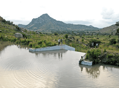
This has real economic consequences. A single river-valley project can irrigate hundreds of thousands of hectares through one dam and one administrative system. A plateau landscape achieving comparable resilience needs thousands of farm ponds, check dams, contour bunds and percolation structures spread across hundreds of micro-catchments, a form of investment that produces no single monument, no inauguration and consequently attracts less political visibility even when its cumulative hydrological impact is greater.
Telangana’s Mission Kakatiya illustrates both the potential and the difficulty of this distributed approach. A 2014 census identified 46,531 minor irrigation tanks across the state for restoration; roughly 22,000 had been restored by March 2023, short of target but still substantial. Independent assessments found irrigation intensity in restored tank commands rising from about 88 per cent to 134 per cent, fish yields up by 36 to 39 per cent and measurable improvement in local groundwater tables, alongside continuing challenges of re-encroachment, inconsistent maintenance and weak engagement of Water Users’ Associations. The key lesson is not that decentralised systems operate effortlessly, but that they depend on sustained institutional arrangements. Their success requires continuous management, similar to that once provided by traditional tank-management systems, rather than the one-off investment characteristic of large capital projects.
The costs of neglecting this capability are visible in the slow substitution of rainfall management by groundwater mining. Nationally, the share of net irrigated area served by groundwater rose from about 38 per cent in 1970–71 to around 64 per cent by 2018–19, even as canal-irrigated area grew only modestly in absolute terms; tanks, once a comparable source of surface storage, have registered a long secular decline over the same period. The Central Ground Water Board’s 2023 assessment classifies about 11 per cent of the country’s 6,553 groundwater assessment blocks as “over-exploited,” concentrated in the north-western, western and southern peninsular hard-rock regions. Read together, these trends describe a slow shift from managing rainfall to mining aquifers, precisely the outcome a landscape-based irrigation philosophy was designed to avoid.
Political incentives compound the problem. Large dams produce a structure a minister can inaugurate and a contractor can build; thousands of decentralised structures, however large their combined hydrological impact, rarely produce comparable visibility. Planning systems reinforce the same tilt because they privilege what is easy to measure: live storage created, canal kilometres built, command area developed. Groundwater recharge, delayed runoff, improved soil moisture and stabilised rainfed yields emerge gradually from hundreds of small interventions and cannot be attributed to any single structure, so they are frequently absent from the metrics that determine budgets. What cannot be measured easily tends to be under-funded, whatever its real contribution to rural welfare.
This is compounded by administrative fragmentation. Plateau hydrology is shaped simultaneously by forests, agriculture, groundwater, soil conservation and local governance, yet a single watershed is typically divided administratively among the irrigation, agriculture, forest, rural development and revenue departments, each with its own budget line and reporting format. Water moves across these boundaries continuously; traditional systems, whatever their inequities, integrated these functions more effectively than the modern administrative structures that succeeded them.
The more useful question for plateau India, then, is not “how do we bring irrigation to this difficult landscape” but “what kind of water system does this landscape already support, and what institutions would let it work.” For nearly a thousand years, rulers across the Deccan, Bundelkhand and Gondwana answered a version of that question successfully; modern Bundelkhand, routinely described as chronically water-scarce, owes at least as much of that scarcity to the decline of its decentralised tank networks as to any change in its underlying climate. The task now is not nostalgia but re-engineering that answer with modern hydrological science, remote sensing and stronger, statutorily backed local institutions capable of the sustained maintenance that distributed systems demand.
Four Irrigation States: A Framework
India’s irrigation history is best read not as a sequence of technologies but as a succession of distinct political economies of water, each with its own planning unit, institutions and measure of success.
Irrigation State I: The Landscape State. Spanning nearly two millennia under diverse regional polities from the Mauryas to the Gonds, its organising principle was ecological rather than technological: different landscapes generated different engineering responses, from tanks on the peninsular plateau to gravity channels in the Himalaya, and the unit of planning was the living watershed itself, sustained through customary rights, labour obligation, religious legitimacy and local governance rather than through any single, exportable design.
Irrigation State II: The Colonial Hydraulic State. The primary objective of irrigation shifted from sustaining landscapes to strengthening the fiscal and administrative capacity of the state. Engineering increasingly meant canals fed by perennial rivers; the planning unit became the project; professional engineering displaced local ecological knowledge; and success was measured through canal construction, irrigated acreage and revenue recovery rather than through the health of a watershed.
Irrigation State III: The Developmental Hydraulic State. Independent India transformed the objectives of irrigation, from revenue to production, from imperial administration to democratic planning, without transforming its institutional architecture. River basins, command areas, engineering departments and capital expenditure remained the organising categories, and “irrigation potential created” became the dominant indicator of success: a reasonable measure for evaluating projects, but a poor one for evaluating the groundwater recharge, soil moisture and ecological resilience of a landscape. The result was extraordinary success in the alluvial basins for which this model was designed, and much weaker performance in the hard-rock, rainfed and plateau regions it was extended to without redesign.
Irrigation State IV: The Landscape Resilience State (proposed). Increasing rainfall variability, groundwater depletion and competing agricultural, urban, industrial and ecological demands make the central question no longer “how much water can we deliver” but “how much water can this landscape retain, recharge and recycle.” This framework does not reject dams or canals; it redefines their role within a broader landscape strategy, and it makes the micro-watershed, comprising ridgelines, lower-order streams, aquifers, fields and forests, rather than the river basin or the individual project, the primary unit of planning.
Towards a Landscape Resilience Framework
A reimagined irrigation policy for India’s rainfed and plateau regions can be organised around five principles.
Water harvesting before water transfer. Every landscape should first maximise productive use of the rainfall it receives before depending on external transfers; rivers merely redistribute rain that has already fallen elsewhere. Rockström and Barron’s cross-country evidence on rainfed systems suggests that supplemental water harvesting, capturing even a fraction of runoff during peak rainfall, can substantially narrow the gap between actual and potential yield in semi-arid conditions, often more cost-effectively than new long-distance transfers.
Recharge before extraction. Groundwater should be treated as a renewable ecological asset rather than a reserve to be mined; investment should favour recharge, spring rejuvenation and aquifer restoration ahead of further extraction, a shift made urgent by the roughly one-tenth of India’s groundwater assessment blocks already classified as over-exploited, concentrated precisely in the hard-rock regions this essay is concerned with.
Distributed storage alongside centralised storage. Large reservoirs remain indispensable in many basins; plateau landscapes additionally need thousands of distributed structures, farm ponds, check dams, percolation tanks and recharge trenches, functioning as an integrated system rather than isolated works, complementing large infrastructure rather than replacing it.
Landscape institutions alongside engineering departments. Effective watershed management requires irrigation, agriculture, forestry, groundwater and rural development departments, along with panchayats, civil society and farming communities, to collaborate rather than operate as separate silos, much as traditional systems once integrated these functions more successfully than the fragmented administration that succeeded them. Mission Kakatiya’s uneven experience with Water Users’ Associations is a reminder that institutional design, not just capital outlay, determines whether restored infrastructure is actually maintained.
Productivity per drop and resilience per hectare. Irrigation policy has rightly emphasised productivity per drop for decades, and this remains essential. Climate change now demands an additional metric: whether a hectare continues to support livelihoods, replenish groundwater, conserve soil and buffer climatic shocks under increasingly erratic rainfall. Productivity measures agricultural efficiency; resilience measures landscape sustainability. Future policy needs both simultaneously, not one traded off against the other.
None of this asks Indian policy to start from zero. The Jal Shakti Abhiyan and its “Catch the Rain” campaign already channel central attention toward renovating traditional water bodies and building local recharge structures; the Atal Bhujal Yojana has demonstrated community-led groundwater management across roughly eighty water-stressed districts; and Mission Kakatiya, whatever its shortfalls against target, remains a rare instance of a state government treating minor irrigation restoration as a flagship, not a residual, programme. What these efforts still lack is a shared measurement framework that would let a tank restored in Telangana, a recharge structure built under Jal Shakti Abhiyan and a watershed treated under a state rural-development scheme be compared, aggregated and evaluated on the same terms that “irrigation potential created” has long provided for large dams. Building that framework, more than any new capital outlay, is the immediate task before policy makers.
None of this requires building new data systems from scratch. India already maintains the Minor Irrigation Census, the Agricultural Census, Central Water Commission reservoir data, India-WRIS geospatial records, FAO AQUASTAT benchmarks and research from ICAR and the International Water Management Institute. What is missing is not data but the institutional will to combine these sources into indicators of landscape performance, rather than treating each irrigation project as a closed, self-contained unit of account.
This is not a marginal technical debate for the country’s tribal and rainfed districts; it is close to the central development question they face. Where major irrigation is physically improbable and financially unjustifiable at the scale required, distributed water harvesting is frequently the only realistic route by which a smallholder or tribal household can add a second crop, stabilise fodder and drinking water through the dry months, or reduce dependence on distress migration. Civil-society and community-based programmes working in tribal plateau districts have shown, often at far lower per-hectare cost than major projects, that lift irrigation, check dams and spring-shed treatment can be built and maintained by farmer collectives when backed by modest, sustained technical support rather than a one-time capital grant. A policy architecture that continues to treat such work as pre-development philanthropy, rather than as legitimate public irrigation investment in its own right, will keep under-serving precisely the regions this essay is concerned with; a Landscape Resilience State would instead recognise it as the primary form irrigation investment ought to take in these landscapes.
Conclusion: Recovering the Ecological Intelligence of Indian Irrigation
This argument is neither nostalgic nor anti-modern. It does not call for abandoning large dams or romanticising a pre-colonial past that was itself unequal and imperfect. It proposes recovering a principle earlier civilisations understood well: technology succeeds when designed around the landscape, not when landscapes are forced to adapt to technology.
Colonial administration transformed irrigation into an instrument of centralised governance; independent India transformed it again into an instrument of national development. Each transition answered the priorities of its time. Climate resilience, groundwater sustainability and livelihood security in rainfed and tribal India define the priorities of this one, and they arrive at a moment when the country can draw on hydrological science, remote sensing and participatory planning methods that earlier irrigation civilisations never had. Meeting them will require engineering that is guided by ecology rather than the reverse; institutions that matter as much as infrastructure; planning that begins with the micro-landscape rather than the mega-project; and a measure of success that counts not only hectares brought under irrigation but the resilience of the landscapes and communities that depend on them.
For policymakers, the key lesson is not necessarily to create new ministries or pass new laws, but to change what is measured, funded and prioritized. For researchers, it means developing ways to measure irrigation and water management at the landscape level rather than focusing only on individual projects. For those working in tribal and rainfed areas, it is a reminder that activities such as desilting tanks, protecting springs and strengthening Water Users’ Associations are not second-rate alternatives to large irrigation projects. They are, and have been for centuries, the forms of irrigation best suited to these landscapes. If the twentieth century built India’s hydraulic state, the twenty-first century must build a state that strengthens landscape resilience; not by returning to the past, but by building on the long history and ingenuity of India’s irrigation traditions.
(The content of this article reflects the views of writer and contributor, not necessarily those of the publisher and editor. All disputes are subject to the exclusive jurisdiction of competent courts and forums in Delhi/New Delhi only)




















Comments (2)
N
Nice article, full of historical insights and timeless wisdom. The article is a fascinating and thought-provoking exploration of India's rich legacy of traditional water harvesting and irrigation systems. It beautifully highlights how communities across diverse ecological regions developed ingenious, locally adapted solutions that sustained agriculture, groundwater, and livelihoods for centuries. These systems reflected not only technical excellence but also strong community ownership and ecological wisdom. The discussion on the colonial period provides an important historical perspective. The shift from community-managed water systems to centralized, canal-based and government-controlled irrigation gradually weakened many traditional institutions and led to the neglect of indigenous water management practices. While large canal networks expanded irrigation in several regions, they often overlooked the ecological diversity and local governance mechanisms that had made traditional systems resilient and sustainable. One of the most valuable insights from the article is that India's water future does not lie in choosing between traditional and modern approaches, but in integrating the strengths of both. Reviving community-managed water structures alongside scientific planning and modern irrigation technologies can significantly enhance water security, climate resilience, and sustainable agriculture. This article is a timely reminder that many solutions to today's water crisis can be found by learning from our own history and respecting the wisdom embedded in traditional knowledge systems.
R
This article has nicely captured the wisdom of our ancestors in managing irrigation systems in India. Traditionally, water structures were created using an ecosystem-based approach and managed through decentralised systems that were closely aligned with local needs and ecological conditions. The advancement of development through modernisation is certainly important to conserve these structures and improve their efficiency. However, the shift towards groundwater-based irrigation, which was seen as a pathway to agricultural development, has resulted in excessive groundwater utilisation. In many parts of India, groundwater exploitation has now reached a critical stage. At the same time, the importance given to the conservation and development of traditional surface water bodies has declined among both government institutions and communities. In the context of climate change, characterised by high-intensity rainfall, flash floods, and increasingly frequent droughts, there is an immediate need to conserve and manage traditional water bodies within each ecosystem. Equally important is the need to transfer this knowledge to the next generation so that they can understand, value, and appreciate the wisdom embedded in these traditional systems. When landscapes are increasingly forced to adapt to standardised technologies and modern interventions, ecosystem-specific farming practices are gradually being replaced by market-oriented agriculture. This can reduce the resilience of communities and create significant challenges for sustaining livelihoods, particularly where livelihoods remain highly dependent on soil fertility and the availability and quality of groundwater. Therefore, the conservation and revival of traditional water management systems, combined with appropriate modern technologies and decentralised community-based management, are essential for building resilient agricultural landscapes and sustainable livelihoods in the face of climate change.